Land Use and
Community Design
This element provides a long-term vision, goals, and policies for Palmdale over the next 20 to 30 years. The overall focus is on how to accommodate change and growth in the city, while preserving and enhancing the features and attributes that make it such a desirable place to live.
Chapter Highlights
Complete Neighborhoods describe places where residents can reach daily amenities, local retail, services, parks, and public facilities within a short 20-minute walk.
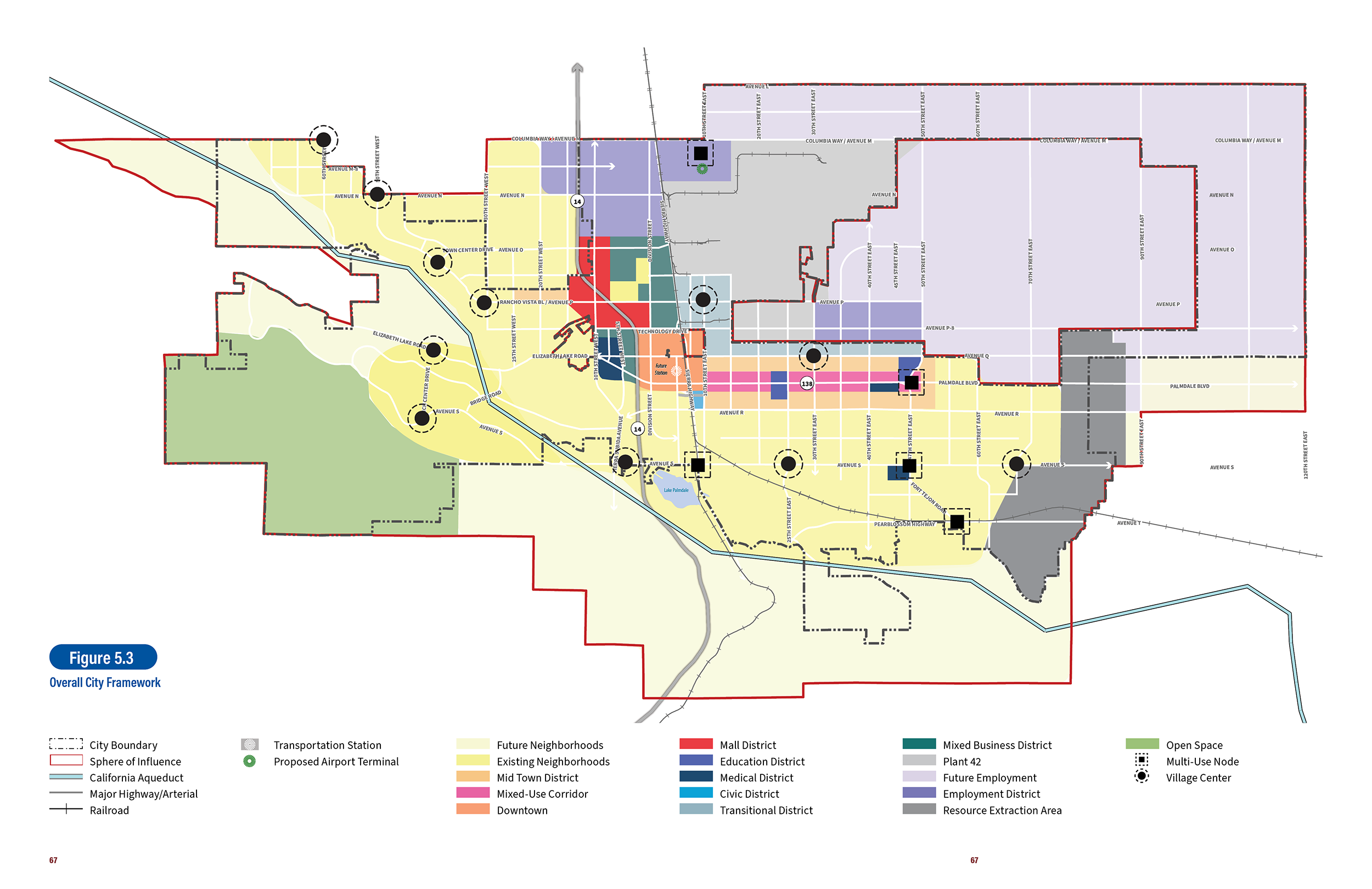
Village Centers offer a mix of daily goods and services within residential neighborhoods in a mixed-use setting. Village Centers support complete neighborhoods by introducing commercial uses within or near residential areas.
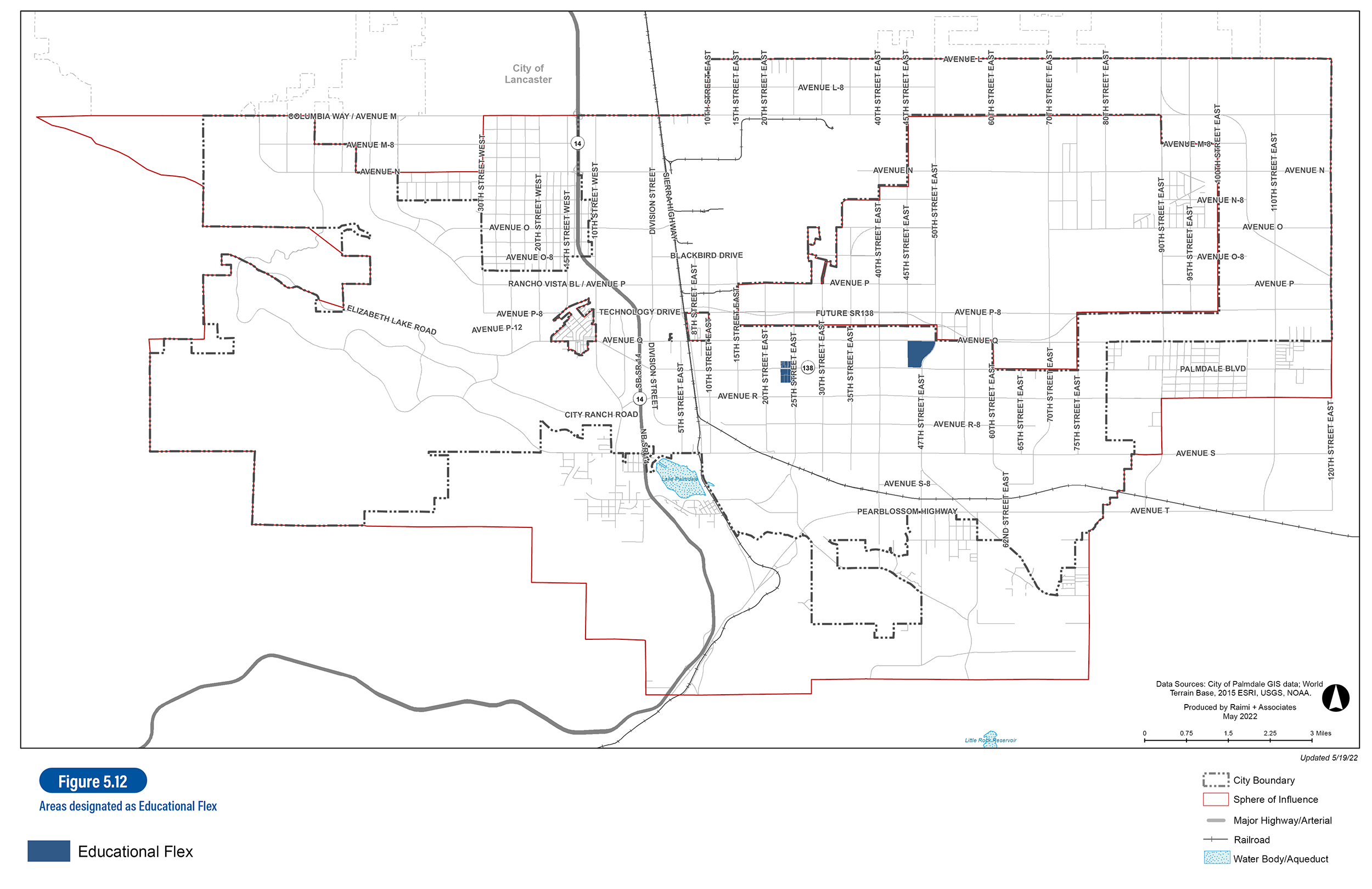
Education Districts designate key locations around the city for higher-education facilities and complementary uses including colleges, trade schools, satellite campuses, supportive retail, office, and housing in a campus-like environment.
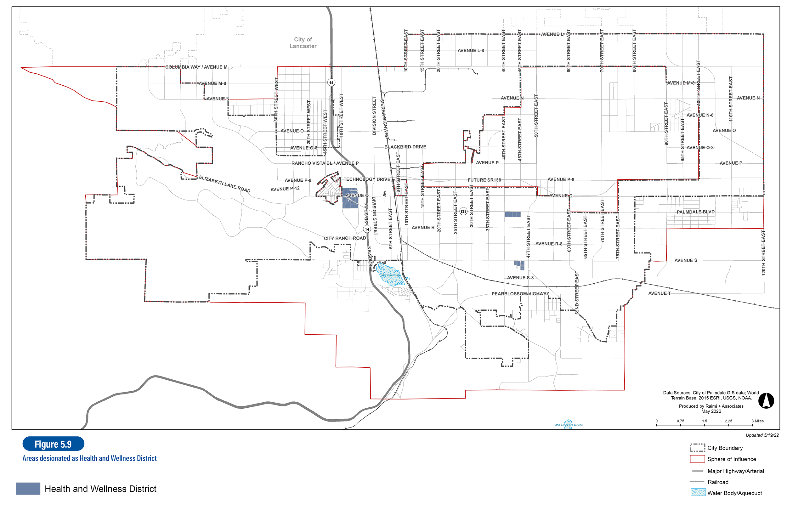
Health and Wellness Districts build off and expand existing medical services in Palmdale. Found in three locations across the city, the Medical Flex designation supports a mix of public and private medical, supportive lodging, offices, and retail.
Learn About
Goals and Policies
Learn About

Citywide Framework
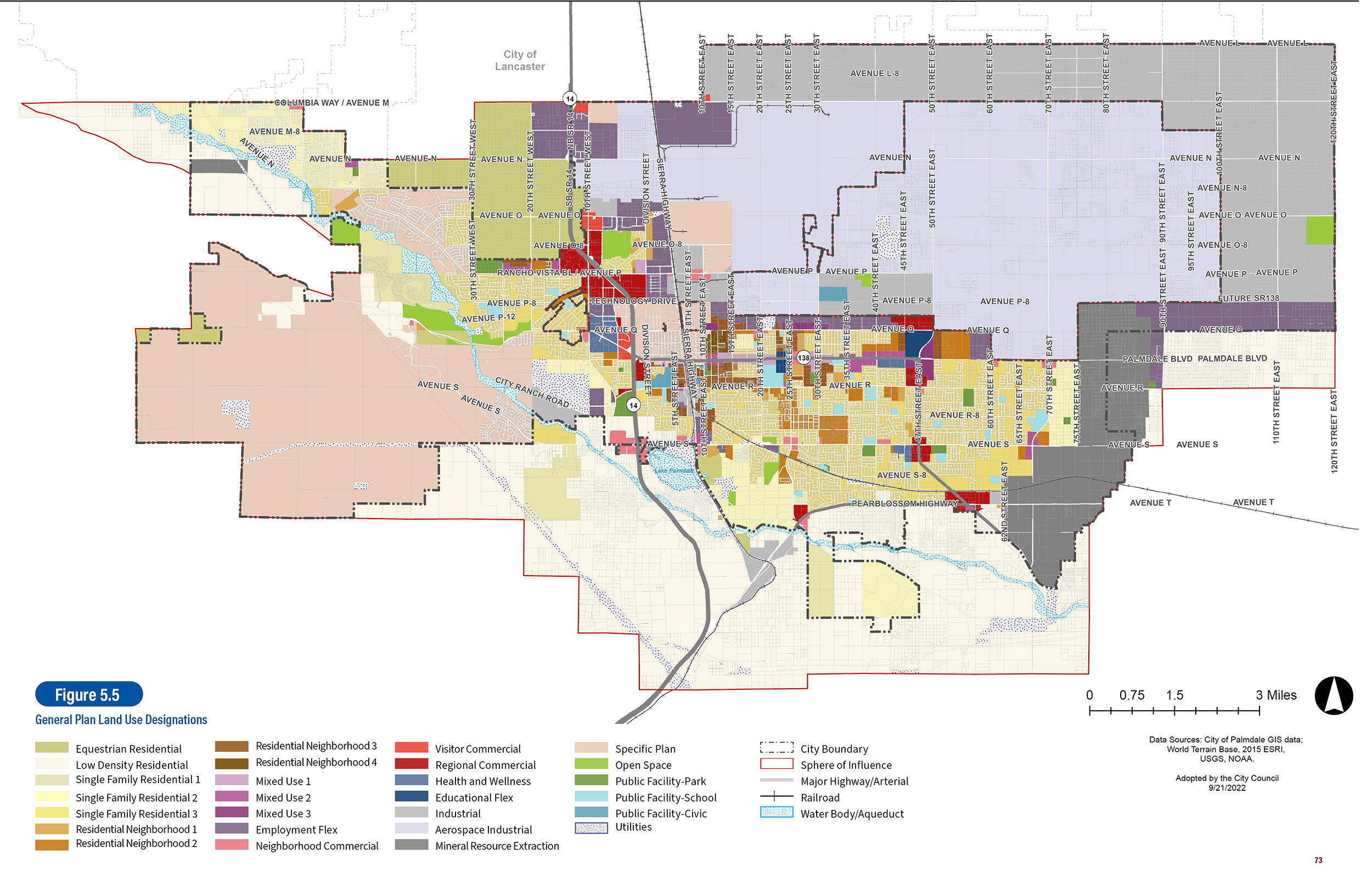
LUD-1.1 Balanced Land Uses. Maintain a balanced land use pattern to support a broad range of housing choices, retail businesses, employment opportunities, educational and cultural institutions, entertainment spaces, and other supportive uses within long-established Palmdale neighborhoods and new growth areas.
LUD-1.2 New Complete Neighborhoods. Facilitate the construction of new mixed-use neighborhoods that are well connected to services, transit, amenities, public buildings, and parks and recreational facilities.
LUD-1.3 Access to Amenities. Strive to create development patterns such that the majority of residents are within twenty minutes or less walking distance of a variety of neighborhood-serving uses in Village Centers, such as parks, grocery stores, restaurants, places of worship, cafes, dry cleaners, laundromats, banks, hair care, pharmacies, civic uses, and similar uses.
LUD-1.4 Specific Plan Facilities. Ensure Specific Plans are implemented with timely construction of supportive commercial uses and parks to support new residential uses.
LUD-1.5 Multimodal Connectivity. Promote walking to services, biking and transit use by requiring a high level of connectivity for pedestrians, bicycles, and vehicles in major developments (except where existing development or natural features prohibit connectivity). Seek to improve walk, bike, and transit travel within existing complete neighborhoods.
LUD-1.6 Walkable Blocks. Create communities that address the needs of multiple age groups and physical abilities through short, walkable block lengths. Use grid-like or a modified grid street networks in newly developed areas (except where topography necessitates another street network layout).
LUD-2.1 Focused Growth. Direct future growth to areas closer to the center of town, which can accommodate development based upon topography, environmental factors, and availability of existing infrastructure.
LUD-2.2 Preferred Development Patterns. In considering requests to amend the Land Use Map, encourage proposals for development in those areas which are functionally connected to developed portions of the city, have available infrastructure, and do not have significant topographic or jurisdictional barriers, or other similar constraints.
LUD-2.3 Discouraged Development Patterns. In considering requests to amend the Land Use Map, discourage proposals for development in those areas which are functionally separated from developed portions of the city by lack of infrastructure, expanses of vacant land, significant topographic or jurisdictional barriers, or other similar constraints.
LUD-3.1 Planned Future Uses. Develop multiple educational districts, multiple medical districts, a new passenger airport, a new high-speed rail facility, and abundant new parks and trails.
LUD-3.2 Accessible Mix of Commercial Uses. Strive to provide goods and services within a short walking distance (twenty minutes or less) of all residents through mixed-use Village Centers and Neighborhood/Regional Commercial uses. Establish neighborhood services by requiring new Village Centers when developing Specific Plan areas.
LUD-3.3 Services and Amenities for Families. Promote opportunities for new childcare and pre-Kindergarten facilities in Village Centers and encourage these supporting uses through the Educational Flex designation.
LUD-3.4 Expansion of Public Facilities. Maintain and expand public facilities and services to better support the community, including schools, libraries, utilities, and recreational spaces.
LUD-3.5 Infrastructure Capacity and Service. Ensure that there will be adequate water and wastewater system capacity to meet projected demand by continuing to oversee the development of adequate and dependable public services and facilities to support both existing and future development.
LUD-3.6 Infrastructure Funding and Programs. Continue to implement comprehensive water and wastewater management programs and ensure that future developments pay their fair share for any infrastructure improvements demand necessary.

Design and Character
LUD-4.1 Quality Construction. Use simple, urban building forms made with permanent materials with high-quality detailing that stands the test of time.
LUD-4.2 Massing Techniques. Use building organization and massing to derive scale and articulation rather than surface ornamentation.
LUD-4.3 Long-Lasting Building Materials. Convey façade articulation through the strength, depth, and permanence of building materials. Thinner cladding materials, such as stucco, masonry veneers, and wood or simulated wood, may be used when finished to appear as durable and authentic as the materials they simulate.
LUD-4.4 Façade Increments. Articulate residential building façades with smaller-scale increments than office and industrial building facades.
LUD-4.5 Attractive Building Entrances. Use visual and physical design cues within the design of a building and within building entries to emphasize the building entrance and connections to public spaces and public pathways/networks.
LUD-4.6 Urban Design in the Core. Require four-sided architecture – all facades of a building are designed with quality, care, and visual interest – in the urban core (primarily RN3, RN4 and MU3). Encourage four-sided architecture in other areas.
LUD-4.7 Iconic Architecture. Allow iconic and memorable building designs, particularly on larger non-residential properties.
LUD-4.8 Environmental Design. Design sites and buildings adjacent to natural areas with transparent design elements. Employ bird-safe design near habitat areas or migratory routes.
LUD-4.9 Public Streetscapes. Create pedestrian-oriented streetscapes by establishing unified street tree planting, sidewalk dimensions and maintenance, pedestrian amenities, and high-quality building frontages in all new development.
LUD-5.1 New Complete Neighborhoods. Require new development to provide multiple amenities, a beautiful public realm, and be consistent with the City’s vision for complete neighborhoods.
LUD-5.2 Walkability of New Neighborhoods. Require all new neighborhoods to be pedestrian friendly by including features, such as short blocks, wide sidewalks, shaded streets, buildings that define and are oriented to streets or public spaces, traffic-calming features, convenient pedestrian street crossings, and safe streets designed for pedestrians, cyclists, and vehicles.
LUD-5.3 Public Services in New Neighborhoods. Require new developments to be designed for and provided with adequate public services and infrastructure. Require that these public facilities and services be provided concurrently with development to ensure a high quality of life for residents.
LUD-5.4 Access to Retail/Services. Strive for a high level of connectivity of residents to neighborhood services through site design, open space linkages, and bicycle facilities. Plan for 90 percent of residents (except for in rural residential designations) to be within a twenty minute walking distance of retail and neighborhood services.
LUD-5.5 Trail Networks. Provide new trails systems that connect to the regional system.
LUD-5.6 Character of New Housing. Provide a diversity of architectural styles; avoid entire blocks or neighborhoods with identical housing styles.
LUD-5.7 Natural Topography. To the greatest extent feasible, preserve natural topographic features during the planning and development process. Utilize physical advantages of the site to minimize visual impacts.
LUD-5.8 Transfer of Development. Require clustered single family and multifamily development in less constrained areas, transferring density from areas constrained by seismic, drainage, rights-of-way, or other conditions based on technical studies.
LUD-6.1 Diversity of Housing Styles. Strongly encourage new subdivisions and master planned projects to include a diversity of housing types and architecture styles, where possible.
LUD-6.2 Primary Entries. Require new homes to provide a primary entryway and windows facing the street.
LUD-6.3 Integrated Pedestrian Circulation. For construction of new small-scale housing and minor subdivision projects, design site plans that provide amenities and integrated networks for walking and bicycling.
LUD-6.4 Recreational Spaces. Improve existing parks and public spaces throughout the city to provide beautiful, comfortable, and inviting gathering spaces.
LUD-6.5 Amenities and Gathering Spaces. Encourage new development to incorporate public plazas, seating, drinking fountains, and gathering places, especially in prominent locations and areas of pedestrian activity.
LUD-6.6 Ongoing Maintenance. Require project developers to establish mechanisms, such as a Community Facilities District, to adequately maintain new parks, recreational facilities, and infrastructure.
LUD-7.1 Safety Programs. Promote Business and Neighborhood Watch programs, in addition to collaborations between residents and law enforcement, to help maintain a clean and safe environment.
LUD-7.2 Crime Prevention. Use Crime Prevention through Environmental Design strategies (CPTED) in new and existing development to improve public safety, including the following:
- Active public space
- Building design to promote “eyes on the street”
- Clear delineation between private and public space
- Natural access control between public and private space
- Maintenance of public places
- Removal or repair of vandalism or broken property
LUD-7.3 Partnerships. Encourage regional partnerships that support the coordination of public safety awareness and crime prevention.
LUD-7.4 Lighting Improvements. Improve lighting and nighttime security across all City neighborhoods to prevent crime and increase safety.
LUD-7.5 Graffiti Removal. Encourage the creation of a graffiti prevention team to remove graffiti from public property (including parks, street signs, sidewalks, etc.) or property adjacent to public rights-of-way.
LUD-7.6. Illegal Dumping. Support systematic removal of unsightly trash/debris and prevention of future illegal dumping. Consider increasing surveillance of known dumping sites, lowering disposal fees at Waste Management sites and raising fines for illegal dumping, and encouraging/facilitating more recycling locally.
LUD-8.1 Arts and Cultural Programming. Expand arts and cultural programming in public spaces, building off the existing Public Art Master Plan.
LUD-8.2 Arts and Gathering Spaces. Encourage new development, especially along Palmdale Boulevard and Avenue Q to incorporate public art in public plazas, seating, and gathering spaces along or near these corridors.
LUD-8.3 Art Priorities. Prioritize art funds from CIP projects to major public gathering spaces, such as parks, public plazas, and along major corridors such as East Avenue Q and Palmdale Boulevard.
LUD-8.4 Art Spaces. Actively encourage affordable arts spaces through use classifications in the zoning code and streamlined permitting in the Light Industrial and Employment Flex zones.

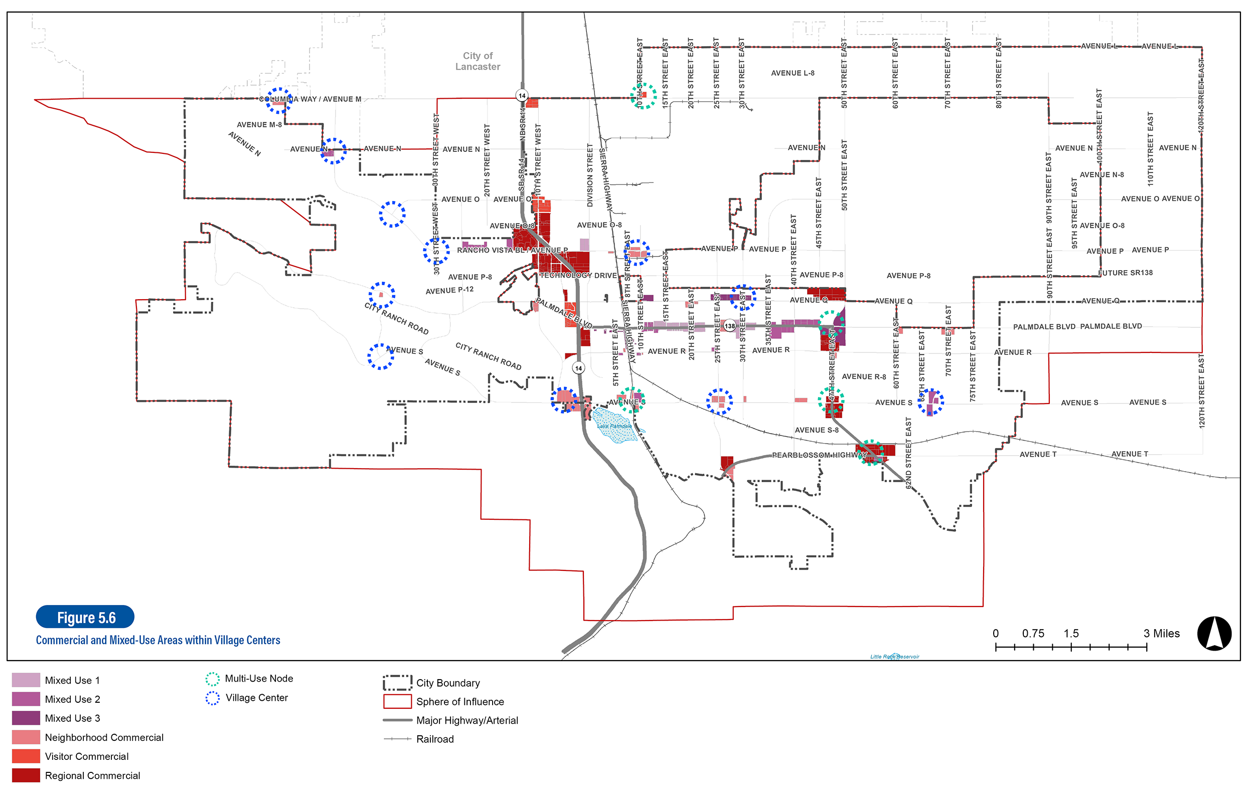
Village Centers and Multi-Use Nodes
LUD-9.1 Activity Centers. Support a network of vibrant Village Centers that are mixed-use activity centers located throughout the City’s residential areas to create 20-minute neighborhoods, implemented through new mixed-use land use designations, which provide a mix of residential uses and daily goods/services.
LUD-9.2 Distinct Character. Encourage design strategies that enhance a unique identity for each of the Village Centers.
LUD-9.3 Gathering Places. Require the introduction of new public gathering places in Village Centers such as publicly accessible plazas or courtyards.
LUD-9.4 Contextual Transitions. Ensure that developments create appropriate transitions to existing residential neighborhoods by placing two-to-three story residential over ground floor retail/services toward arterial streets and lower scaled housing abutting existing residences.
LUD-9.5 Mobility Connections. Seek to improve walk, bike, and transit access to Village Centers by connecting to the larger/regional pedestrian and bicycle networks.

Downtown/PTASP District
LUD-10.1 Mix of Destinations. Develop mixed-use retail, residential and office buildings in the vicinity of the future multimodal high speed rail station to establish the area as a regional and local destination.
LUD-10.2 Places for the Community. Develop community gathering spaces including plazas and neighborhood parks near the future multimodal transit station, in order to evolve the relocated Palmdale Transportation Center into an attractive and unique transit gateway.
LUD-10.3 Transit-Supportive Densities. Support minimum development densities/intensities in the PTASP area to promote sufficient development that allows active placemaking.
LUD-10.4 Station Access. Enhance transit and pedestrian linkages to surrounding areas to create a multi-modal transit and pedestrian-oriented center.
LUD-10.5 Avenue Q Revitalization. Reinforce Avenue Q with development patterns that create a “Main Street” environment. Design the buildings facing Avenue Q (and to a lesser extent 6th Street East and 3rd Street East) to reflect the vision for a new “Main Street” – active uses, street-oriented entrances, tall floor-to-ceiling heights, reduced setbacks (unless adjacent to a plaza or park).
LUD-10.6 Pedestrian-Oriented Design. Implement urban design guidelines and features that encourage pedestrian activity and reduce automobile use.
LUD-10.7 Local Employers within PTASP. Continue to provide assistance to support small locally owned businesses and develop a mechanism to support building upkeep and maintenance, signage, and façade improvements for businesses in the PTASP area.

Palmdale Boulevard Corridor
LUD-11.1 Street Ownership Reclamation. Consider pursuing a long-term take-over of the public right-of-way (ROW) from Caltrans.
LUD-11.2 Critical Place-making Intersections. Strengthen and enliven existing portions of the corridor as pedestrian-oriented community anchors with a mix of civic, commercial, and residential uses, particularly at the intersections with 10th, 20th, and 25th Streets.
LUD-11.3 New Nodes. Create new places for recreation and gathering along Palmdale Boulevard by supporting new nodes of neighborhood-serving mixed-use activity at 40th and 47th Streets East.
LUD-11.4 Corridor Mixed-Use. Revitalize and activate existing commercial shopping centers along the corridor by allowing residential uses in the Mixed-Use 1 and Mixed-Use 2 designations, and by adopting development standards that promote reduced setbacks, stronger pedestrian orientation, high transparency, and architectural detail, and “park-once” behavior.
LUD-11.5 Urban Canopy. Require new development or major additions to existing development to provide street trees at regular intervals (average spacing of no less than 40 feet, not counting driveways) along the property frontage facing Palmdale Boulevard and cross-streets (if on a corner).
LUD-11.6 No Truck Route. Develop an alternative route for trucks to use in place of Palmdale Boulevard between East 50th Street and SR-14, in order to eventually remove the truck route designation currently in place, which would eliminate heavy thru truck traffic along the Boulevard.
LUD-11.7 Palmdale Boulevard Design Guidelines. Design for active, park-once mixed-use and shopping environments by encouraging adherence to the following guidance:
- Locate attached middle-density housing near existing residential uses and seek to integrate it into this context.
- Buildings should be placed at the edge of the primary sidewalk in order to provide interest and immediate access by pedestrians.
- Parking should be located behind the buildings.
- Where appropriate, building setbacks should be flexible to accommodate the need for pedestrian-oriented commercial uses.
- Facades should be activated with frequent building entrances for residential and commercial spaces.
- Mid-block paseos should be added where feasible to provide pedestrian connections from sidewalks along the edge or exterior of a site to parking within the interior of the block

Health and Wellness District
LUD-12.1 Flexible Medical-Oriented Vision. Allow and encourage a mix of public and private medical, health, and wellness uses including emergency medical facilities, medical supportive offices, healthcare clinics and pharmacies, and ancillary retail and services.
LUD-12.2 Regional Hospital. Support the expansion of the existing Palmdale Regional Medical Center (Palmdale Boulevard and 10th Street West) through City investments/improvements and regulatory changes.
LUD-12.3 New Districts. Facilitate the creation of two new health and wellness districts:
- Along Palmdale Boulevard and 40th/45th Streets East
- Adjacent to Kaiser Permanente (East Avenue S and 45th Street East)
LUD-12.4 Health and Wellness District Guidelines. Enable creation of comprehensive medical districts by encouraging adherence to the following guidance:
- Buildings should be located near or at the sidewalk to shape the district’s edges and streetscapes.
- Developments must include open space areas for congregating and socializing, ideally framed by buildings with storefronts or lobbies.
- Joining several blocks together as a campus environment with pedestrian-only spaces and pathways connecting buildings to one another and to surrounding streets is encouraged.
- Buildings should be arranged to form a street wall when surrounding internal parking, with liner uses/buildings that activate the edges of the district. The pedestrian experience should still be supported in the interior of larger blocks.
- Building entrances should always be accessed directly from the sidewalk, via shopfronts or forecourts/lobbies.

Education Districts
LUD-13.1 Educational Focus. Attract a mix of educational uses like trade schools, public and private higher education facilities, and satellite campuses in the Educational Flex land use designation.
LUD-13.2 Appropriate Secondary Uses. Allow and encourage supportive retail, offices, and housing. This may include student or teacher housing, group housing, administrative or research offices, restaurants/cafes, boutiques, banks, personal services, and similar uses.
LUD-13.3 New Institution. Seek to attract a new major higher education institution (such as a nursing school or technical/vocational academy).
LUD-13.4 Locations. Encourage the formation of two education districts:
Near Antelope Valley College Palmdale Center and Palmdale High School (Palmdale Boulevard and 25th Street East); and,
In the vacant area on the northwest corner of Palmdale Boulevard and 47th Street East
LUD-13.5 District Design. Develop an attractive campus-like setting, prioritizing pedestrian and bicycle mobility and providing public open spaces at regular intervals.
LUD-13.6 Educational District Design Guidelines. Enable the creation of uniquely walkable and active educational centers by encouraging adherence to the following guidance:
- Prioritize how educational and supportive uses integrate with the surrounding neighborhood.
- Education Districts should be anchored with major academic institutions to create vibrant, mixed-use destinations.
- The district should be configured in an urban format of walkable blocks, attractive streetscapes, and buildings close the sidewalk edge, though there may be a row of surface parking and landscaping between the buildings and the sidewalk.
- District streets should be connected to neighborhood streets to provide convenient access for nearby residents as well as motorists dropping off students.
- Parks and athletic facilities should be accessible and usable by the public.

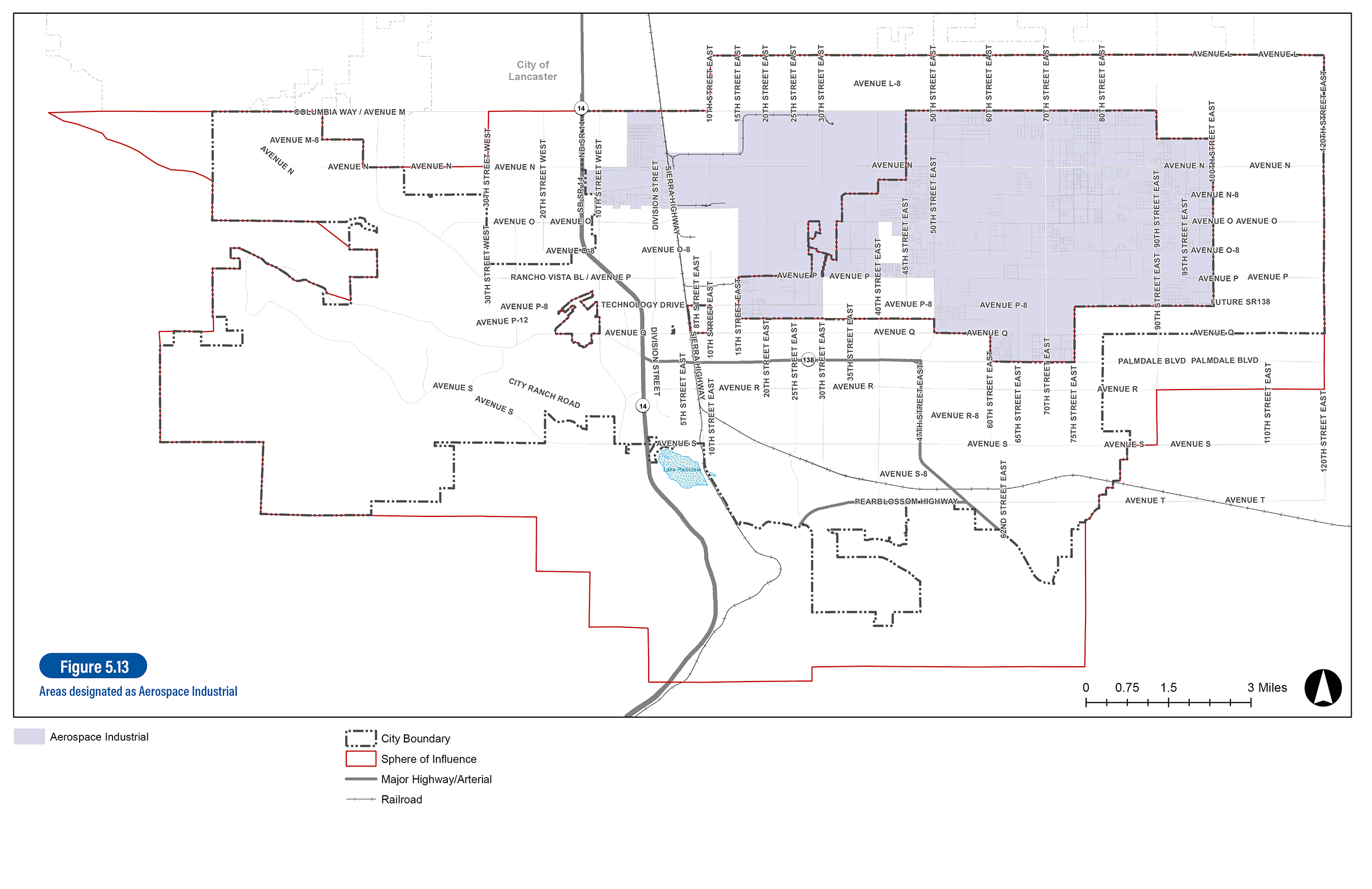
USAF Plant 42 (Aerospace)
LUD-14.1 Safeguarding Plant Operations. Support continued growth of Plant 42 operations in the Aerospace Industrial land use district. Maintain sufficient land to accommodate a wide variety of industrial uses to meet military and community needs.
LUD-14.2 Adjacent Use Compatibility. Continue to buffer this area from adjacent, non-compatible residential and commercial uses.
LUD-14.3 Limited Non-Industrial Uses. Prevent non-industrial uses from locating in the Aerospace Industrial area (aside from uses that directly support Plant 42 or airport operations).
LUD-14.4 Accident Prevention. Avoid residential uses greater than one dwelling unit per acre in the Accident Prevention Zones (APZs).
LUD-14.5 Circulation and Access. Maintain vehicular infrastructure and improve circulation to accommodate the unique demands of aerospace workplaces.

Antelope Valley Mall
LUD-15.1 Destination Land Uses. Allow a diverse range of retail, dining, and entertainment establishments of any size that help create a destination for Antelope Valley residents and visitors.
LUD-15.2 Residential Land Uses. Allow a broad range of low to medium-density residential at the Antelope Valley Mall as a part of a comprehensive development plan prepared for the mall property. Proposed residential uses on this site are subject to the following standards:
- Any proposal to introduce housing in the Mall site must be accompanied by a comprehensive development plan that provides details on phasing, connectivity, mobility, wayfinding, and other key programmatic and urban design components.
- Avoid locating new residential uses within 500 feet of SR-14 right-of-way.
LUD-15.3 Coordinated Evolution. Work with the Mall operator and property owners to effectuate long-term redevelopment of existing retail into new, higher-density developments such as multistory retail or mixed-use retail with office or residential above. Actively solicit new employment uses, with a focus on office, medical, film, and related uses.
LUD-15.4 Regional Mall Design Guidelines. Guide the redevelopment of big-box retail into more urban, mixed-use formats by encouraging adherence to the following guidance:
- Arrange mixed-use buildings, liner-type buildings, and other active frontages to form an occasional street wall when surrounding an internal parking lot or structure.
- Ensure active frontages and pedestrian-oriented design for any redevelopment of commercial uses at the mall, to eliminate unsightly blank walls and facades.
- Setbacks to internal streets should be less than setbacks to external/arterial streets.
- Major internal drives should include sidewalks on both sides, detailed and landscaped as small streets.
- Building entrances should be accessed directly from the sidewalk, and sidewalks in front of major shops should be as wide as possible. Awnings should be utilized to provide shade for pedestrians.

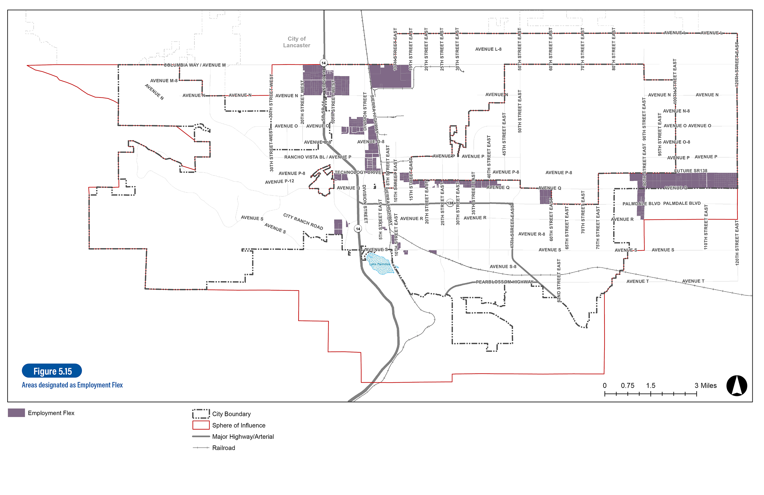
Employment Areas
LUD-16.1 Healthy Balance of Jobs. Strive for a ratio of at least 1 job per employed resident (which effectively means growing jobs faster than housing during the Plan timeframe).
LUD-16.2 Employment Diversity. Support a diverse mix of light industrial, information, film, makerspace, boutique food/wine/beer processing, local food, and technology uses to provide jobs and tax revenues for the community by allowing emerging economic uses and industries within the Mixed-Use and Employment designations.
LUD-16.3 Flexible Designation. Diversify the City’s economic base by expanding the number of facilities on land designated as Employment Flex to accommodate film, technology, food/light manufacturing, and service tenants.
LUD-16.4 Makerspaces. Encourage collaborative workspaces with tools for the design, prototyping, and creation of manufactured products for sale.
LUD-16.5 Home Businesses. Support home businesses that meet City planning and permitting requirements and create jobs and opportunities for entrepreneurship.
LUD-16.6 Increased Employment. Recruit employment uses between Avenue Q and Avenue P/Rancho Vista Boulevard.
LUD-16.7 Industrial Incentives. Promote establishment of incentives for new light industrial development in Palmdale including the use of local, state, and federal programs.
LUD-16.8 Emerging Technology. Support new technologies that may increase business opportunities in the city, such as autonomous vehicles.
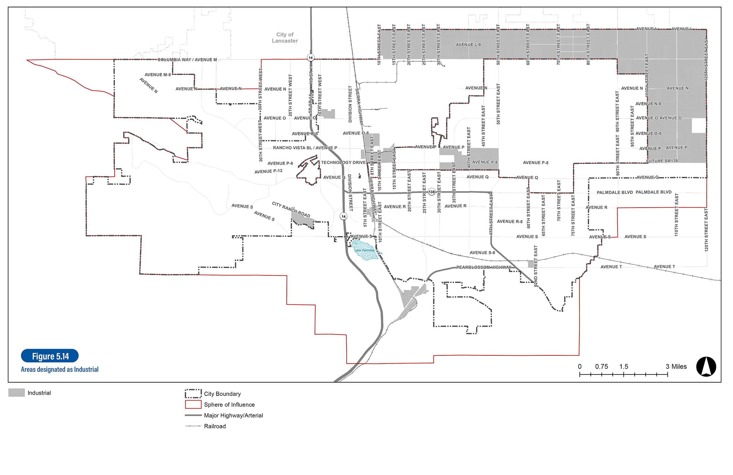
LUD-17.1 Retention of Businesses. Minimize land use compatibility conflicts that discourage attraction and retention of production, distribution, and service and repair businesses in areas zoned for industrial use.
LUD-17.2 Infrastructure Master Planning. Encourage master planning and infrastructure funding districts within industrial areas to ensure adequate and comprehensive provision of infrastructure and efficient, attractive designs, through cohesive planning of larger development projects.
LUD-17.3 Industrial Development Standards. Adopt development standards for industrial uses near residential uses, to ensure compatibility and aesthetically pleasing views from adjacent rights of way, including but not limited to standards for screening of outdoor storage, locations of loading and refuse disposal areas, height, bulk, impervious surface area, architectural enhancement, landscaping, and other measures as deemed appropriate.
LUD-18.1 Flexible Standards. Establish flexible development standards in the Employment Flex designation that allow industrial uses to make building improvements and change with market conditions. Incentivize growth of office and commercial spaces suitable and affordable for local businesses through development requirements.
LUD-18.2 Middle-Income Employment. Expand a core area of light industrial and service uses that provide middle-income jobs for Palmdale residents.
LUD-18.3 Residential Adjacencies. Buffer heavy industrial uses and light industrial uses, such as general services, light manufacturing, and storage uses from residential neighborhoods.
LUD-18.4 Parking Requirements. Adjust zoning and parking requirements as necessary to ensure reinvestment can occur in buildings while maintaining industrial uses.
LUD-18.5 Parcel Aggregation. Encourage lot assembly to allow businesses to grow and expand.
LUD-19.1 On-Site Processing. The use of imported raw materials should be avoided and only materials available on-site should be processed.
LUD-19.2 Focused Land Use District. Ancillary uses should be only those typically associated with extraction and/or processing of on-site materials, including uses such as paver and precast concrete facilities.
LUD-19.3 Nuisance Control. Ensure that measures to control noise, dust and erosion/sedimentation are applied to on-going mining activities.
LUD-19.4 Screening. To the extent feasible, require screening of equipment, stockpiles, or waste piles from public view.
LUD-19.5 Mining Site Access. Evaluate truck access to and from the site in order to reduce impacts generated by truck traffic, such as road deterioration, noise, and safety concerns, which affect nearby residents.
LUD-19.6 Reclamation Fund. Establish a use-based mechanism for mining operators to begin contributing to a reclamation fund annually to be used after operations cease.

New Residential Neighborhoods
LUD-20.1 Revised Specific Plans. When modifications to an adopted Specific Plan are proposed, require the plans to adhere to the following:
- Provide connections to regional trails and natural open spaces for all residential units.
- Create protections for western Joshua trees and other critical desert species.
- Review compliance with the City’s Hillside Ordinance for viewshed protection.
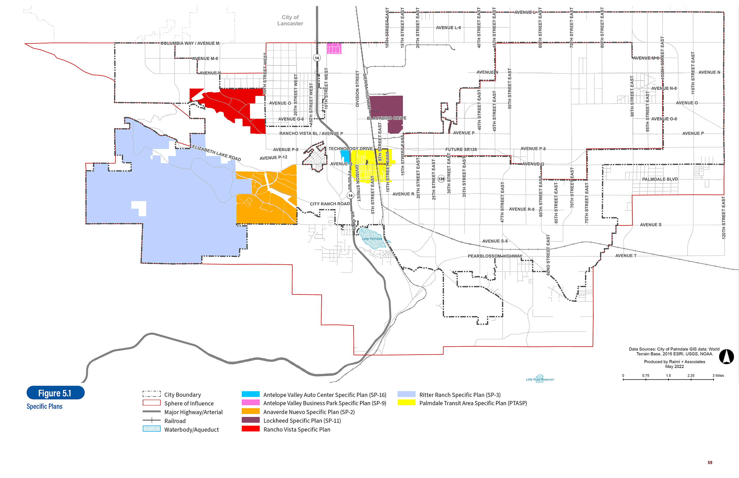
LUD-20.2 New Village Centers. Ensure the creation of new Village Centers organized around a central focal point such as a park, school, civic building, or neighborhood retail as development occurs in Specific Plan areas, including:
- Anaverde Nuevo Specific Plan
- Ritter Ranch Specific Plan
- Rancho Vista Specific Plan
LUD-20.3 Planned Developments. Encourage the creation of new Village Centers in Planned Development (PD) areas, including Quail Valley PD, Joshua Ranch PD, Aero PD, and The Strata PD.
LUD-21.1 Timing of Community/Retail Uses. Require development of commercial uses and amenities during key phases of buildout of residential portions of a Specific Plan.
LUD-21.2 Clustered Development. Require rural neighborhoods and clustered development in steeper and topographically constrained areas and use these development types to preserve significant natural amenities.
LUD-21.3 Respecting Natural Ridges. Avoid grading or siting of dwelling units on the north facing side of Ritter Ridge or other major ridgelines.
LUD-21.4 Greenbelt Concept. Strive to create an undeveloped or natural greenbelt around the city comprised of natural areas, parks, open space, and agricultural/utility lands.

Existing Neighborhood Improvements
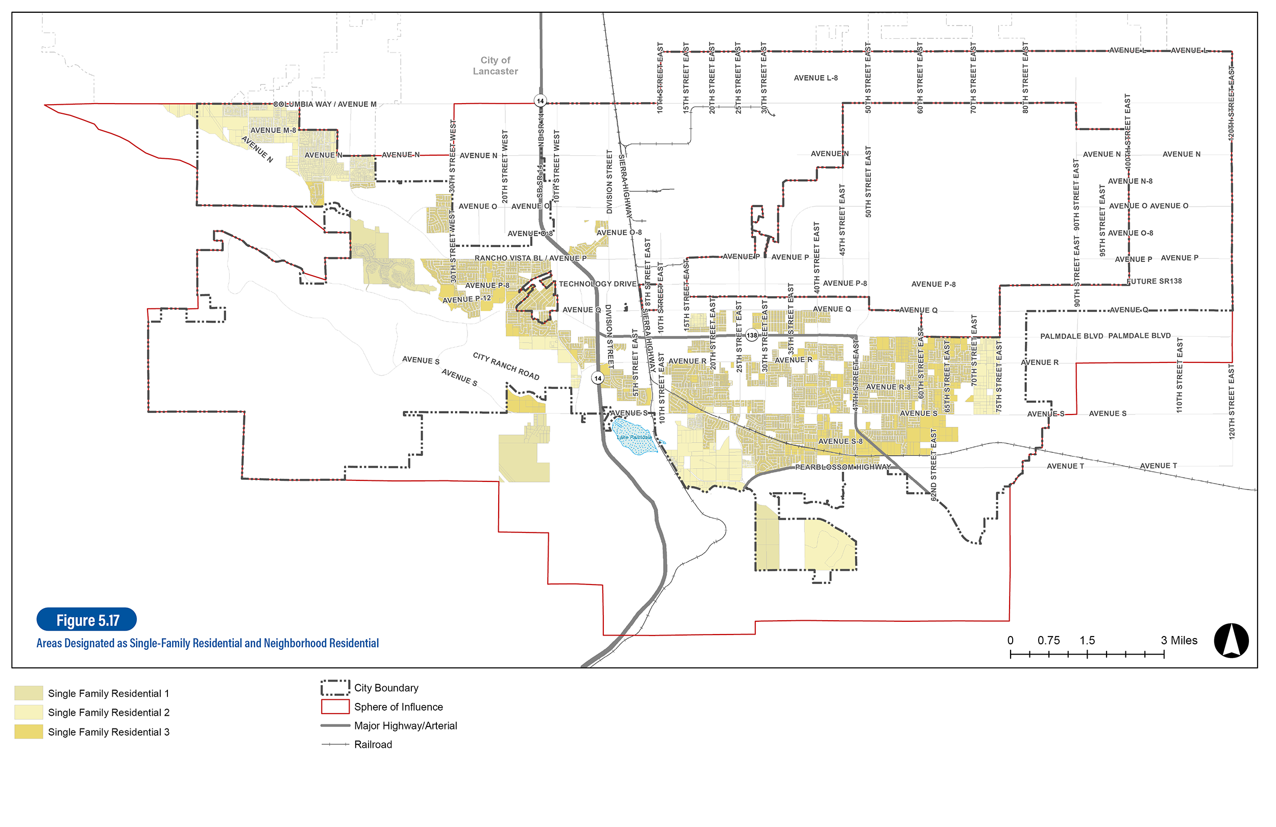
LUD-22.1 Mixed-Density Residential. Promote residential infill development, where appropriate, as indicated by the mixed-density Residential Neighborhood land use designations (RN1, RN2, RN3, RN4).
LUD-22.2 Infill Priority. Maximize opportunities for residential development through infill and redevelopment of vacant parcels by facilitating parcel aggregation and streamlining permit processing for infill applications.
LUD-22.3 Distributed Higher Density. Permit a range of residential densities and housing types throughout the city rather than concentrating higher densities in limited areas.
LUD-22.4 Transit-Oriented Density. Direct the location of senior and multifamily housing to areas accessible to public transportation, supportive commercial uses, and community facilities.
LUD-22.5 Varying Housing Types. Encourage and allow a variety of housing types developed at a range of densities to serve varying household types, including, but not limited to, single-family attached and detached, accessory dwelling units, multifamily apartments, townhomes, duplexes, triplexes, quadplexes, and condominiums.
LUD-22.6 Special Needs Housing. Facilitate housing for special needs groups, including the developmentally disabled, and non-traditional family groups by allowing a diverse range of housing configurations that are Americans with Disabilities Act (ADA) compliant and flexible.
LUD-22.7 Senior Housing. Promote development of housing types that support multi-generational households, senior housing, and opportunities for seniors to age in place.
LUD-23.1 Connections to Existing Neighborhoods. Provide pedestrian/bicycle connections to trails and open space where appropriate and indicated in past planning efforts.
LUD-23.2 Multimodal Streets. According to the General Plan street hierarchy, require key boulevards and neighborhood connectors to be (re)designed, constructed, and operated as multimodal streets, not wide, high-speed streets.
LUD-23.3 Connectivity Enhancements. Introduce new public trail systems that connect to the regional system through Capital Improvement Projects, private development projects and city/regional parks improvements.
LUD-23.4 Quarter-Mile Radius. Work toward a goal of having 90 percent of residents living within twenty minutes walking distance of a dedicated park, school, or multi-use trail.
LUD-24.1 Appropriate Densities. Avoid designating land for higher density uses where prevailing existing development patterns are rural residential with lot sizes of one acre or more.
LUD-24.2 Commercial Developments. Permit neighborhood commercial development within rural areas to serve the needs of these areas, provided that such projects include safe, logical, and functional access from the adjacent neighborhoods for pedestrian and equestrian users.
LUD-24.3 Septic Requirements. Enforce Los Angeles County standards and requirements regarding septic systems.
LUD-24.4 Avenue S and SR-14. Require that development near the intersection of Avenue S and SR-14 is complementary to Lake Palmdale, surrounding hillside, and mountain views by minimizing building heights and viewshed impacts; and is consistent with sound water quality management practices by providing a minimum 100-foot setback from the historical high-water mark of Lake Palmdale and meeting other relevant environmental standards.
LUD-24.5 Landfill Buffer. Provide a 1,000-foot buffer between Antelope Valley Landfill operations and residential developments.
LUD-24.6 Potential Annexation. Consider annexation as a last resort option and only as a logical extension of the City boundaries as neighboring properties are annexed and adjacent properties are developed. Before initiating annexation, evaluate the fiscal, infrastructural and land use impacts of proposed annexations to the City, as well as the desires of inhabitants within the areas to be annexed.
My Neighborhood Map
Desired Targets and Outcomes
OUTCOME: Attract more jobs to promote Palmdale as a complete city.
Space
KEY PERFORMANCE INDICATOR:
- Jobs/housing balance.
Space
TARGET:
- Reach a 1 to 1 balance. The GPU 2045 projections call for 22,000 new homes and 26,750 new jobs to move the city closer to a 1 to 1 ratio.
OUTCOME: Continue to expand Palmdale’s aerospace industry to attract skilled employment and achieve the associated fiscal benefits.
Space
- Square footage of airport/military industrial uses.
Space
TARGET:
- Continued expansion of aerospace industrial and supportive industrial uses (per the 2045 Growth Projections)
OUTCOME: Attract new types of economic activity to buttress Palmdale against a downturn in any particular industry or sector.
Space
KEY PERFORMANCE INDICATOR:
- Diversity of employment use.
Space
TARGET:
- Increased diversity in the types of jobs and employers.
OUTCOME: Leverage the predicted strong market demand for medical office, remote work, educational space, aerospace support, start-up space, etc.
Space
KEY PERFORMANCE INDICATOR:
- Square footage of office uses.
Space
TARGET:
- Substantial growth of office uses, especially medical offices (per the 2045 Growth Projections).
OUTCOME: To diversify the City’s housing stock, provide more housing options, and specifically address the previous gap in allowed housing densities (between 16.1 and 30 dwelling units per acre), which functionally limit development of rental housing/apartments.
Space
KEY PERFORMANCE INDICATOR:
- Increase the number of multifamily housing units.
Space
TARGET:
- Increasing multifamily housing units as a share of all residential development by 2045.
OUTCOME: Take advantage of new transit investments by locating enough new residential units at moderate densities in and around the area, and to generate vibrancy and a sense of place.
Space
KEY PERFORMANCE INDICATOR:
- New housing units in the Palmdale Transit Area Specific Plan.
Space
TARGET:
- Achieve the residential growth projections for the PTASP by 2045.
OUTCOME: Establish new and strengthen existing Village Centers at the heart of 20-minute neighborhoods to increase availability of daily services, provide convenient multimodal access to amenities and offer the potential to reduce Vehicle Miles Traveled.
Space
RATIONALE:
- Walkability/proximity to services in Village Centers. A Complete Neighborhood is one where residents can reach community amenities (e.g., grocery stores and retail), public facilities (e.g., parks and community centers) and services (e.g., health care and childcare) within a 20-minute walk
Space
TARGET:
- Increase the number of existing homes that are located in a “20-minute neighborhood.”
OUTCOME: Attract more jobs to promote Palmdale as a complete city.
Space
KEY PERFORMANCE INDICATOR:
- Jobs/housing balance.
Space
TARGET:
- Reach a 1 to 1 balance. The GPU 2045 projections call for 22,000 new homes and 26,750 new jobs to move the city closer to a 1 to 1 ratio.
Space
OUTCOME: Continue to expand Palmdale’s aerospace industry to attract skilled employment and achieve the associated fiscal benefits.
Space
KEY PERFORMANCE INDICATOR:
- Square footage of airport/military industrial uses.
Space
TARGET:
- Continued expansion of aerospace industrial and supportive industrial uses (per the 2045 Growth Projections)
Space
OUTCOME: Attract new types of economic activity to buttress Palmdale against a downturn in any particular industry or sector.
Space
KEY PERFORMANCE INDICATOR:
- Diversity of employment use.
Space
TARGET:
- Increased diversity in the types of jobs and employers.
Space
OUTCOME: Leverage the predicted strong market demand for medical office, remote work, educational space, aerospace support, start-up space, etc.
Space
KEY PERFORMANCE INDICATOR:
- Square footage of office uses.
Space
TARGET:
- Substantial growth of office uses, especially medical offices (per the 2045 Growth Projections).
Space
OUTCOME: To diversify the City’s housing stock, provide more housing options, and specifically address the previous gap in allowed housing densities (between 16.1 and 30 dwelling units per acre), which functionally limit development of rental housing/apartments.
Space
KEY PERFORMANCE INDICATOR:
- Increase the number of multifamily housing units.
Space
TARGET:
- Increasing multifamily housing units as a share of all residential development by 2045.
Space
OUTCOME: Take advantage of new transit investments by locating enough new residential units at moderate densities in and around the area, and to generate vibrancy and a sense of place.
Space
KEY PERFORMANCE INDICATOR:
- New housing units in the Palmdale Transit Area Specific Plan.
Space
TARGET:
- Achieve the residential growth projections for the PTASP by 2045.
Space
OUTCOME: Establish new and strengthen existing Village Centers at the heart of 20-minute neighborhoods to increase availability of daily services, provide convenient multimodal access to amenities and offer the potential to reduce Vehicle Miles Traveled.
Space
RATIONALE:
- Walkability/proximity to services in Village Centers. A Complete Neighborhood is one where residents can reach community amenities (e.g., grocery stores and retail), public facilities (e.g., parks and community centers) and services (e.g., health care and childcare) within a 20-minute walk
Space
TARGET:
- Increase the number of existing homes that are located in a “20-minute neighborhood.”